Showing posts with label quake. Show all posts

Friday, January 20, 2012

Warning Signs from the Cascadia Subduction Zone?


California Earthquake Map
CaliforniaEarthquake Map 01/20/2012
On January 17, 2012 a 4.3 magnitude earthquake occurred on the Cascadia Subduction Zone off the coast of Northern California. This relatively small quake could signal movement on this dangerous fault which has historically been silent between large events.

Lurking offshore of Northern California and running north toward Vancouver, Canada, lies the Cascadia Subduction Zone. This fault has the potential to produce an earthquake and tsunami as devastating as the March 11, 2011 quake that struck off Honshu, Japan. 

While the San Andres fault system has produced a long and obvious scar on the landscape of California and the frequency of small to moderate, non-damaging earthquakes has drawn the attention of the media and scientists, Cascadia remains locked quietly offshore for centuries, building stress until it suddenly releases in massive quakes.

Geological evidence shows seven great quakes have occurred along Cascadia in the last 3500 years. Intervals range from 200 to 900 years with most occurring around 300 years apart.


Cascadia Subduction Zone
Cascadia last ruptured in January, 1700, producing an estimated 9.0 magnitude quake.  Recently researchers have shown the chances of a major quake occuring along Cascadia could be as high as 45 percent within the next 50 years.

Between these major quakes, Cascadia sits virtually silent. In fact, scientists were aware of its presence in the Pacific northwest, but it was not considered a threat as it appeared to never experience quakes.

Brian Atwater's 2005 study of drowned coastal forests lead to the discovery of Cascadia's hidden threat. It appears to remain virtually locked and silent for centuries, pressure and stress building until it is released in a giant quake.

According to Iris, Incorporated Research Institution for Seismology:
"...Just a quarter century ago, hardly anyone suspected that a giant underwater earthquake – or the fast-arriving tsunami that such an earthquake would spawn – could ever occur in the Pacific Northwest. The region’s written history, which begins a few decades before the arrival of Lewis and Clark, is devoid of such catastrophes. Yet today the Northwest has a widely acknowledged history, thousands of years long, of earthquakes as large as magnitude 9 and of associated tsunamis. "
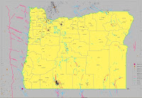
Oregon Earthquake Map
Oregon Earthquakes1841 - 2002
Movement on the Cascadia has been virtually non-existent for more than a century. This map shows seismological history of Oregon for the time period from 1841 through 2002. Note the red line running north/south off the Pacific coast. This represents the Cascadia fault. Note the earthquakes occur near, but not on the fault itself.

Now look at this USGS map showing the Cascadia fault registering a 4.3 magnitude earthquake on January 17, 2011. This is a highly unusual place for movement to occur. The map also shows several small quakes in the days before the larger one.

Foreshocks, Aftershocks or Anomaly?

Large Earthquakes are often preceded by 'foreshocks' which can occur from minutes to even years before the main shock. They occur in about forty percent of moderate to large quakes and perhaps seventy percent of quakes greater than magnitude 7.0.

Studies show foreshocks may increase in intensity over time leading to the main quake:
    "The observation of foreshocks associated with many earthquakes suggests that they are part of a preparation process prior to nucleation. In one model of earthquake rupture, the process forms as a cascade, starting with a very small event that triggers a larger one, continuing until the main shock rupture is triggered. "
Cascadia quake
4.3 Cascadia quake 01/17/2012
Unfortunately it is not possible to know if a particular quake is part of a foreshock pattern until after a main event occurs.

Aftershocks are smaller quakes which occur as plates readjust following a larger event. They decrease in frequency as time passes.

Perhaps the small quakes in the preceding days were foreshocks to a main 4.3 quake on the 17th? This is certainly possible, however if the 4.3 was the culmination of this series, it should have been followed by decreasing aftershocks as the huge plates settled back into a locked position. There have been no such aftershocks.

Earthquake prediction is notoriously unreliable. Tantalizing hints of patterns give hope that someday we may be able to recognize the precursors to great quakes and evacuate populations before they strike.

The question arises: Is Cascadia stirring? The recent anomalous quake on the fault is noteworthy if only for its rarity.

There are great concerns that this area is not prepared for a quake of historical size. Cities from Eureka, California to Vancouver, Washington are potential targets.

Tsunami Evacuation Route, Oregon
According to Peter Yanev, an engineer and earthquake building consultant in this article:
    "... ...Pacific Northwest cities are full of buildings with slender structural frames and fewer and smaller shear walls. In a mega-quake, many of the region's iconic tall buildings would probably collapse. "
The Cascadia Region Earthquake Workgroup has prepared a hypothetical scenario of the effects of a rupture of Cascadia. Predictions include:
"...• Depending on location, strong shaking might be felt for several minutes.
• Injuries and fatalities could number in the thousands, and
hundreds of buildings could be destroyed.
• A destructive tsunami will quickly hit the Cascadia coast
and travel across the Pacific Ocean.
• Aftershocks up to M7 are common, creating the potential
for additional damage."
Without a doubt, the Cascadia Subduction Zone will someday unleash a great quake in the Pacific Northwest. The odds may be as high as 45% that it will strike during the lifetime of todays residents. Whether the quake that occurred on January 17 was a foreshock, aftershock or simply an anomaly, Cascadia will rupture someday. Perhaps it will happen tomorrow or a decade from now. Please prepare now. The clock is ticking.

Plan Ahead:
Disaster Preparedness Kits from Amazon
DIY Disaster Preparedness Kits


images: Oregon quake history: http://www.oregongeology.com/sub/earthquakes/eqepicentermap.htm
Cascadia Subduction Zone: http://en.wikipedia.org/wiki/Cascadia_subduction_zone
tsunami evac: http://www.flickr.com/photos/cornelii/2066817391/sizes/m/in/photostream/
Cascadia_subduction_zone: http://en.wikipedia.org/wiki/Cascadia_subduction_zone

Tuesday, November 8, 2011

Flurry of Earthquake 'Anomolies' Caused by Fracking?

Seismograph
Update: March 9, 2012:
A series of Ohio earthquakes were caused by fracking according to State officials. Tough new laws will regulate drilling and disposal of waste.*

The 5.6 earthquake which struck Oklahoma in late 2011 was the latest in a string of 'rare' earthquakes shaking the normally geologically quiet interior or North America.

These previously unusual events are raising fresh concerns that the use of fracking and the disposal of fracking fluids may be causing the quakes.

Fracking is the fracturing of layers of rock with high pressure fluids to release pockets of trapped gas and oil. Increases in energy prices and Bush era deregulation has led to a wide use of this technique with thousands of new wells brought on line in the past few years.

This proliferation in fracking has coincided with numerous earthquakes in unusual locations. Recent studies indicate that culprit may actually be the disposal wells. Fracking produces lots of waste fluid which is collected and injected at high pressures into disposal wells.

Earthquakes caused by this type of wells is not the paranoid imaginings of environmental zealots. In this recent report, the Oklahoma Geological Survey studied a swarm of earthquakes in Garvin County, OK in January of this year, which began within hours of a new and deep hydro-fracturing project nearby.
The Geological Survey stopped short of definitively blaming the earthquakes on the fracking operation, but noted
"...The strong correlation in time and space as well as a reasonable fit to a physical model suggest that there is a possibility these earthquakes were induced by hydraulic-fracturing."
Typically, the report concludes that it is impossible to say definitely if the quakes were caused by fracking, but other locations hit by anomalous quakes are satisfied they have enough proof.

In June of this year, Cuadrilla Resources was forced to suspend its' fracking operation after it admitted it caused a swarm of earthquakes in normally seismically peaceful northwest England.

February, 2011: Arkansas Oil and Gas Commission issued an emergency moratorium on new injection wells due to a 4.7 magnitude quake as part of a suspicious swarm of earthquakes in the area.

In August of 2009, Chesapeake, one of the largest oil and gas exploration companies in the area, was forced to shut down two wells in the Dallas/Fort Worth area after they were linked to a swarm of earthquakes.

In other events, fracking was suspected, but no action taken:

Drilling Rig
In October 2011, a rare 4.8 magnitude quake hit in near San Antonio, Texas. This occurred in an area which has been heavily drilled and fracked.

In August of 2011, a rare 5.8 quake hits Virginia and is felt all over the east coast. Speculation ensues that dramatically increased fracking in the area may have triggered this rare event.

The same day, a southern Colorado 5.3 earthquake occurred in the same area as a swarm of possible fracking induced quakes investigated in 2001 by the USGS. Three months before the August 2011 quake, the EPA announced plans to study the impacts of fracking on drinking water in that area.

No one knows the impact of the large-scale fracturing of the earth's crust or the ramifications of high pressure injection of waste fluids deep underground. The evidence is mounting of a direct connection between these practices and unusual earthquake activity, but it may be impossible to scientifically prove.

These strange quakes have caused quite a bit of damage but no deaths so far. Energy companies continue to deny any connection between earthquakes and fracking or disposal of fracking fluids. The evidence, however, continues to pile up.

How many 'rare' earthquakes does it take before we acknowledge a pattern? And what price are we willing to pay, in lives and property, for the promise of 'cheap' energy?

*Update: March 09, 2012:
A series of Ohio earthquakes were caused by fracking according to State officials. Tough new laws will regulate drilling and disposal of waste.

In this report, the Ohio Department of Natural Resources said:
"After investigating all available geological formation and well activity data, ODNR regulators and geologists found a number of co-occurring circumstances strongly indicating the Youngstown area earthquakes were induced," state officials stated. "Specifically, evidence gathered by state officials suggests fluid from the Northstar 1 disposal well intersected an unmapped fault in a near-failure state of stress causing movement along that fault."

Article first published as Flurry of Earthquake 'Anomolies' Caused by Fracking? on Technorati.

images:
drill rig: http://commons.wikimedia.org/wiki/File:Drilling_for_gas_and_oil_in_Dalby_Forest_February_2007_-_geograph.org.uk_-_343560.jpghttp://commons.wikimedia.org/wiki
seismograph: http://commons.wikimedia.org/wiki/File:Kinemetrics_seismograph.jpg