Showing posts with label earthquake. Show all posts

Friday, January 20, 2012

Warning Signs from the Cascadia Subduction Zone?


California Earthquake Map
CaliforniaEarthquake Map 01/20/2012
On January 17, 2012 a 4.3 magnitude earthquake occurred on the Cascadia Subduction Zone off the coast of Northern California. This relatively small quake could signal movement on this dangerous fault which has historically been silent between large events.

Lurking offshore of Northern California and running north toward Vancouver, Canada, lies the Cascadia Subduction Zone. This fault has the potential to produce an earthquake and tsunami as devastating as the March 11, 2011 quake that struck off Honshu, Japan. 

While the San Andres fault system has produced a long and obvious scar on the landscape of California and the frequency of small to moderate, non-damaging earthquakes has drawn the attention of the media and scientists, Cascadia remains locked quietly offshore for centuries, building stress until it suddenly releases in massive quakes.

Geological evidence shows seven great quakes have occurred along Cascadia in the last 3500 years. Intervals range from 200 to 900 years with most occurring around 300 years apart.


Cascadia Subduction Zone
Cascadia last ruptured in January, 1700, producing an estimated 9.0 magnitude quake.  Recently researchers have shown the chances of a major quake occuring along Cascadia could be as high as 45 percent within the next 50 years.

Between these major quakes, Cascadia sits virtually silent. In fact, scientists were aware of its presence in the Pacific northwest, but it was not considered a threat as it appeared to never experience quakes.

Brian Atwater's 2005 study of drowned coastal forests lead to the discovery of Cascadia's hidden threat. It appears to remain virtually locked and silent for centuries, pressure and stress building until it is released in a giant quake.

According to Iris, Incorporated Research Institution for Seismology:
"...Just a quarter century ago, hardly anyone suspected that a giant underwater earthquake – or the fast-arriving tsunami that such an earthquake would spawn – could ever occur in the Pacific Northwest. The region’s written history, which begins a few decades before the arrival of Lewis and Clark, is devoid of such catastrophes. Yet today the Northwest has a widely acknowledged history, thousands of years long, of earthquakes as large as magnitude 9 and of associated tsunamis. "
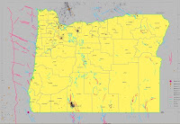
Oregon Earthquake Map
Oregon Earthquakes1841 - 2002
Movement on the Cascadia has been virtually non-existent for more than a century. This map shows seismological history of Oregon for the time period from 1841 through 2002. Note the red line running north/south off the Pacific coast. This represents the Cascadia fault. Note the earthquakes occur near, but not on the fault itself.

Now look at this USGS map showing the Cascadia fault registering a 4.3 magnitude earthquake on January 17, 2011. This is a highly unusual place for movement to occur. The map also shows several small quakes in the days before the larger one.

Foreshocks, Aftershocks or Anomaly?

Large Earthquakes are often preceded by 'foreshocks' which can occur from minutes to even years before the main shock. They occur in about forty percent of moderate to large quakes and perhaps seventy percent of quakes greater than magnitude 7.0.

Studies show foreshocks may increase in intensity over time leading to the main quake:
    "The observation of foreshocks associated with many earthquakes suggests that they are part of a preparation process prior to nucleation. In one model of earthquake rupture, the process forms as a cascade, starting with a very small event that triggers a larger one, continuing until the main shock rupture is triggered. "
Cascadia quake
4.3 Cascadia quake 01/17/2012
Unfortunately it is not possible to know if a particular quake is part of a foreshock pattern until after a main event occurs.

Aftershocks are smaller quakes which occur as plates readjust following a larger event. They decrease in frequency as time passes.

Perhaps the small quakes in the preceding days were foreshocks to a main 4.3 quake on the 17th? This is certainly possible, however if the 4.3 was the culmination of this series, it should have been followed by decreasing aftershocks as the huge plates settled back into a locked position. There have been no such aftershocks.

Earthquake prediction is notoriously unreliable. Tantalizing hints of patterns give hope that someday we may be able to recognize the precursors to great quakes and evacuate populations before they strike.

The question arises: Is Cascadia stirring? The recent anomalous quake on the fault is noteworthy if only for its rarity.

There are great concerns that this area is not prepared for a quake of historical size. Cities from Eureka, California to Vancouver, Washington are potential targets.

Tsunami Evacuation Route, Oregon
According to Peter Yanev, an engineer and earthquake building consultant in this article:
    "... ...Pacific Northwest cities are full of buildings with slender structural frames and fewer and smaller shear walls. In a mega-quake, many of the region's iconic tall buildings would probably collapse. "
The Cascadia Region Earthquake Workgroup has prepared a hypothetical scenario of the effects of a rupture of Cascadia. Predictions include:
"...• Depending on location, strong shaking might be felt for several minutes.
• Injuries and fatalities could number in the thousands, and
hundreds of buildings could be destroyed.
• A destructive tsunami will quickly hit the Cascadia coast
and travel across the Pacific Ocean.
• Aftershocks up to M7 are common, creating the potential
for additional damage."
Without a doubt, the Cascadia Subduction Zone will someday unleash a great quake in the Pacific Northwest. The odds may be as high as 45% that it will strike during the lifetime of todays residents. Whether the quake that occurred on January 17 was a foreshock, aftershock or simply an anomaly, Cascadia will rupture someday. Perhaps it will happen tomorrow or a decade from now. Please prepare now. The clock is ticking.

Plan Ahead:
Disaster Preparedness Kits from Amazon
DIY Disaster Preparedness Kits


images: Oregon quake history: http://www.oregongeology.com/sub/earthquakes/eqepicentermap.htm
Cascadia Subduction Zone: http://en.wikipedia.org/wiki/Cascadia_subduction_zone
tsunami evac: http://www.flickr.com/photos/cornelii/2066817391/sizes/m/in/photostream/
Cascadia_subduction_zone: http://en.wikipedia.org/wiki/Cascadia_subduction_zone

Sunday, November 6, 2011

What Went Wrong at Fukishima? 24 Hours to Meltdown

Reactor 3 Explodes at Fukishima
A report by the IEEE (Institute of Electrical and Electronics Engineers) takes a close look at what went wrong at the Fukishima Nuclear Power Plant following the March 11, 2011 earthquake and tsunami.
 
With billions of dollars in research and technology invested in nuclear energy, the report identified six common-sense and seemly obvious lessons which could have minimized or prevented the impending meltdown.

A massive 9.0 quake struck at 2:46 pm on March 11, 2011 off the east coast of Japan. At the Fukushima Dai-ichi Nuclear Plant, operated by Tokyo Electric Power Co. (TEPCO), Unit numbers 1,2 and 3 of the six reactors were operating. #4, 5 and 6 were down for scheduled maintenance. The quake caused the plant to perform a routine auto-shutdown without incident.

Power outages caused by quake were widespread. Within 10 seconds, twelve diesel generators activated to power water pumps for cooling to the fuel rods. So far, all emergency procedures are working as planned.

At 2:52 pm Unit 1 using a non-electrical isolation condenser (IC) backup cooling system was cooling the reactor too quickly and a plant supervisor shut it down, per normal procedure.

Tsunami alerts predicted a 3 meter (9.8ft) high wave would strike the Fukushima prefecture. The Dai-ichi Plant is 10 meters above sea level (33 ft). For safety, non-essential personnel began evacuating plant.

The first wave struck at 3:27. With a second set of much bigger waves arriving at 3:35 pm. It has been approximately fifty minutes since the quake.

The second huge wave topped seawalls and surged through plant. It destroyed heat removal seawater pumps and inundated the control rooms controlling valves, pumps and other crucial equipment. Later, TEPCO employees would estimate the killer wave at 14 meters high (46 ft) from water stains on the walls.

Six generators located in basements were drowned and five more shut down when control rooms were flooded. Only one generator serving reactors 5 and 6, not located in a basement, continued operating. This lone functioning generator helped units 5 and 6 survive the disaster while the other reactors spiraled out of control.

Lessons from Fukishima
Even back up batteries failed and Reactor 1 suffered a complete power failure. The control room went dark and instrument panels stopped functioning. Cooling system pumps failed and the water which was supposed to be cooling radioactive fuel rods began to boil. Steam built inside the reactor building. Without working gauges and instruments, operators were not sure of how much water was left to cool the rods.

The non-electrical IC cooling system serving Reactor 1 had been shut down early in the crisis, due to it working too well. Now, without power,  plant operators were unable to reopen the valves, even manually.

Operators struggled to regain power at the plant.  They scavenged batteries out of cars in the parking lot and called out a small fleet of power-generating trucks. However,  the earthquake and tsunami ruined roads and mass evacuations clogged highways and these trucks promptly became stuck in traffic.

At 4:36 TEPCO finally officially alerted the Japanese government of the problem at Reactor 1.

Around 9 pm and working by flashlight, operators ingeniously powered up a few important instrument panels using the scavenged car batteries and were relieved to see that the water cooling the fuel rods in Reactor 1 seemed to holding up so far. Water levels were down, but the rods were not exposed.

Later, company analysis showed the instruments were incorrect. The water level had dropped so low the rods were completely exposed. Temperatures had topped 1300 °C (2372 °F) and the meltdown had already begun.

Around midnight, more instruments were brought online and showed that dangerous pressure inside the containment vessel had already exceeded its' maximum design and an explosion was a serious risk.

Teams struggled through the night and next day to vent the explosive pressure in the containment vessel and cool the rods. Power trucks finally arrived and prepared to restart pumps cooling the crippled reactor.

Fire hoses poured on fresh water until tanks were empty, then in desperation started using highly corrosive sea water. This was an tacit admission that saving the plant was no longer an option and now the focus was on preventing a massive nuclear disaster.

Unknown to operators, the meltdown was proceeding. Superheated fuel rods had begun to melt through the steel floor of the pressure vessel. Pressure built inside the reactor as residents within a 10 km area around the plant (6.2 miles) were evacuated.

Attempts to release the pressure from hydrogen gas inside the reactor continued but were not enough to prevent a catastrophic explosion almost exactly 24 hours after the tsunami hit the plant.

The explosion cut off power from the trucks and severed the fire hoses. The flow of cooling water ceased as radiation levels climbed and plant operators scrambled for safety.

The disaster continued to spiral out of control. The plant was now a radioactive hot spot and choked with debris from the tsunami and explosion of reactor 1. Workers struggled to cool Reactors 2 and 3, but without power or pumps, Reactor 3 exploded on March 14, followed by a possible explosion inside number two later that day. Later, another explosion tore the roof off building four.

As this slow-motion catastrophe unfolded, workers fought gallantly to contain it but efforts were continually hampered by the lack of power which caused pumps to fail and rendered safety controls useless. Japanese officials later admitted that three reactors suffered full meltdowns.

Certainly, lessons will be learned from this disaster. Nuclear Power Plant designers worldwide will be studying Fukishima for years to come and will develop better system designs and disaster plans.

But looking at how events unfolded, it was mainly a lack of planning in the common-sense, low tech processes which brought Fukishima to its' knees.

Article first published as What Went Wrong at Fukishima? 24 Hours to Meltdown on Technorati. 

Images:
Reactor 3 image: http://en.wikipedia.org/wiki/File:Fukushima_I_by_Digital_Globe.jpg

Lessons background image: http://www.flickr.com/photos/bagalute/5127578547/sizes/m/in/photostream/